The rain it raineth every day…

..every.single.day.

While we’re still bothering to pay meteorologists, I suppose there’s some comfort to be had from knowing it’s at least going to be no worse than this until the end of the century…particularly if you live on top of one of the only hills for 50 miles around. Like Normanby-le-Wold, for example:

Yes, only 550 feet above sea level, but high enough to get an air traffic control radar station:

Or possibly a device to enable the US government to monitor your Twitter account, depending on your point of view…

Anyway, there’s a village here..and a Church – another “murder most Fowler”:

According to the blurb in the Church’s leaflet,  the “Normanby” part of the name indicates it was -at the time – a village settled by Norsemen (Norwegians), as named by (and thereby differentiated from) the Danes who occupied most other surrounding settlements. The “Le Wold” part was apparently a relatively recent adoption, as it was once more usually known as ‘Normanby-on-the-Hill’, to distinguish it from the three other Normanbys in the county.

There was once an Anglo-Saxon church here (and an Anglo Saxon farmstead and nearby burial pit were excavated nearby in the late 1960s), but no trace of it remains. The present population seems to be, once again, considerably less than that recorded in the Domesday book; the immediate village consisting now of about half a dozen “gentrified” buildings, and presumably the farmer who sees fit to let his cattle turn a public footpath into a quagmire of mud and slurry, in that petty-minded way that makes farmers so beloved the world over.

Next to the church, as you can see here – across the beautifully-kept churchyard – is an 18th century brick building originally used as a Sunday School (http://en.wikipedia.org/wiki/Sunday_school) but which later became a shed for storing a threshing machine:

So, then, the architecture of the present church – again, according to the leaflet  – suggests it dates from the 13th century and was, as usual, built from the local ironstone which seems to have a durability just above that of cinder toffee. In 1296, there was a ‘scandalous incident’ recorded here, when a gang of  men burst into an evening service and roughed up the rector, Gilbert of Lafford, and his clerk. Nobody knows why, but the men concerned – “sons of Belial, stirred up by a diabolical spirit” – were duly excommunicated.

A decline in population led the church to gradually fall into relative disuse, and part of it was even demolished. However, an increase in population during the later Victorian era caused the parish to vote for a thorough restoration which was carried out – in 1867/8 – by our old friend-of-the-Gothic and local architect, James Fowler who did a very reasonable job, for the £1,000 cost incurred. The south aisle and the lower portions of the church tower are all that remains of the 13th century building; the rest is his work.

I have to say, the interior is one of the most pleasant I’ve seen so far of any of the local parish churches I’ve wandered around in. Very pleasing to the eye, and neither cold nor damp:

My camera, with its own relentless digital drive for ‘optimising’ everything, doesn’t really do the place justice, as it looked then in the mellow evening light, however much I struggled with it:


The most striking thing about the interior, however – immediately entering through the door – is the collection of three large Victorian medieval-style paintings that hang on the walls. It seems they were salvaged, somehow, from a church in Burton on Trent, in Staffordshire:

Left to right: St Faith (holding the grid-iron on which she was roasted to death); Moses, with tablets; Christ; Aaron; St Martin of Tours.

The second painting, above the doorway to the tower, depicts the entry into Jerusalem:

Apparently, this is Christ being begged by St Peter to calm a storm on the Sea of Galilee, with St Werburgh (left) and St Boniface of Devon (right), looking on.

Licence my roving hounds and let them go…

I took the dogs for their walk just north of Welton le Wold, starting here at this derelict one-storey Victorian cottage:

Always a sad sight. It stands on its own, by the road, opposite some woodland and the start of a bridleway:

It’s still surprising, to me, how quickly even a sturdily built place like this can fall down, once Nature’s regained a firm hold. This is how the north end gable looked in 2009 and then yesterday:


The young sycamore trees growing in the bedroom are no more than 15 years old, I’d say; and there is still ash piled in the fireplace, so I don’t think it was all that long ago that it was inhabited. Since there is no trace of any smashed tiles or rotten roof timber on the floor, it suggests to me the materials of the roof were removed and used elsewhere,  after it was abandoned, which would obviously have opened it up all the sooner to the elements, as well as sycamore seeds.

You can’t help wondering about the lives of people who lived in places like this, in any case, but cottages on their own, like this, are almost never simply dwellings. Dwellings huddle together in hamlets and villages, in this part of the world. ‘Isolated’ cottages are usually linked to a specific job the place was tied to, and had to be located nearby. In this case, I think the cottage housed an employee of the old sand and gravel quarry that used to be just up the road, though what their actual job may have been, I couldn’t even hazard a guess. The dates would more or less fit, as it seems the quarry opened somewhere around 1870, and closed in 1970.

It stretches quite a way, on the west side of the road, and a little way to the eastern:

They chopped the end off the spur, and turned it into aggregate, basically. Sand and gravel from here eventually built the airfield runways of bomber command hereabouts, during WWII but, by 1970, it was all finished. It was finally bought by the county’s Wildlife Trust in the early 2000’s, who now keep it as a reserve, with no public access but, before Nature was allowed to reclaim it, teams of geologists and archaeologists had the chance to set up camp and dig around for a bit. They found flint tools- some of the oldest traces of man ever discovered this far north of the Thames, -as well as the fossilised remains of straight-tusked elephant, horse and bison.

The dogs and I carried on along the bridleway until we found the opportunity to cross a hay meadow where they had the freedom to run around to their hearts’ content. As it was a hot day, for a change, that didn’t take all that long:

Among the meadow flowers were:

Over the rise and along the edge of another dreary cornfield, and then we joined a lane where the hedgerows were full of roses:


Here G, his path strewn with rose petals, cools his toes and wonders how the day might be improved…

Off the beaten track…

Welton le Wold is all over the place, historically speaking. Its very name – with the French “le” intruding between the two English words – gives a  snapshot of the post-Conquest Norman-French administrative need to differentiate it from the county’s other Weltons: the Welton near Lincoln, and the Welton le Marsh…..out on the marshes.

In 1066, with 14 villagers and 20 freemen, 40 acres of meadow and ploughland enough to keep almost 6 teams going, it was a sizeable place; its lord was Queen Edith no less; thereafter William the Bastard/Conqueror himself, according to the Domesday Book.

The hamlet now is a quiet and still proseperous-looking ‘ribbon village’ (that is a settlement where the dwellings mostly congregate along either side of a single thoroughfare, with few -if any- other roads or side roads) down in a valley, below the one of the main coast roads and away from any significant traffic:


“stately trees making a magnificent aisle of the steep hillside down to the church” Arthur Mee’s King’s England 1949

The church is dedicated to St Martin.  The tower is 14th century, built of much-weathered ironstone rubble, the rest of the church having been completely rebuilt in 1849 by S.S. Teulon (before Fowler had the chance to get at it).


The door is solid oak, of course, and quite short and squat; but look at the ironwork:

Just inside, is the font – as old as the tower – with a huge, heavy spire-like cover held up from a large iron bracket on the wall. I have no idea why.


Local residents have evidently done very well in maintaining the inside of the church, with the north aisle refurbished for ‘community use’:

There is a list, on one wall, of all the “clergy in charge” dating back to 1190. Between 1696 and 1722,  the rector was Suffolk-born Laurence Echard. Though a busy churchman, he was much better known as an historian, whose History of England was a standard text of its day. Among other works, he also wrote a “Roman History” in 1696. It was written for the education of Queen Anne’s son, William the “Duke of Gloucester”, who unfortunately “danced himself to death” in 1700, aged 11 and presumably didn’t get much use out of it.

Volume II – covering the more colourful emperors, Augustus, Tiberius,  Caligula and so on – was the most popular, not surprisingly, and went through many editions, including the one I found a copy of, from 1706:

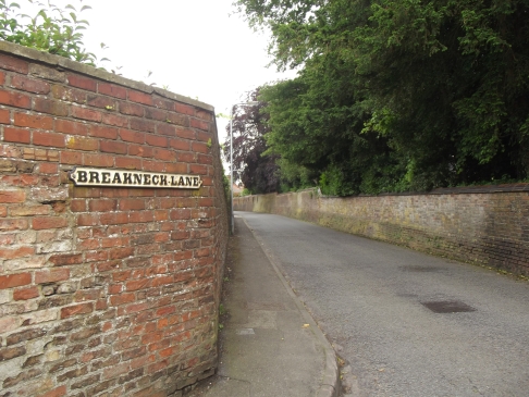
Breakneck Lane & other spots…

At the other end of Westgate, from the church, another road merges from the left:

Image

How the road came to be so-named is lost in the mists, but the high walls and the sudden sweep of the lane after the straight downhill race of Edward Street could well have caused it to be something of an ‘accident black spot’ in coach & horses days. In any case, it is said to be haunted by the sound of galloping hooves. At the top of the lane was the goose pool that gave Gospelgate its name, as mentioned, and beyond that, on Edward Street and along Crowtree lane are the main buildings of the Grammar School:

Apart from Alfred Lord Tennyson, other Old Ludensians include: Sir John Franklin (the explorer who perished in the frozen northern wastes, along with the rest of his expedition, looking for the North West Passage); Captain John Smith (of Pocahontas fame, and first Governor of Virginia); and Michael Foale (astronaut and first Brit in Space).

http://www.kevigs.org/#/recruitment/4535082150

Down Crowtree Lane, past some very nice houses and an old water mill…

…we finally arrive at the largest gift that came out of Auguste Pahud’s legacy: Hubbard’s Hills. It is a park made out of a glacial valley down which the Lud now lazily meanders:


http://www.hubbardshills.co.uk/history.phtml

Following the river, briefly back into town, we cross Westgate Fields:


..to what are now a group of cottages and flats, but which used to be The Old Trout Farm:

..and which was, in the sixteenth century, the site of a carpet factory. This diversion of the water must have been useful for both functions:

Up the hill and round the corner from here, the road leads westwards out of town and past Thorpe Hall:

The Hall was originally built in 1584 by Sir John Bolle. Sir John became a soldier and, in 1596, was present at the Siege of Cadiz:

As the story goes, plain John Bolle actually received his knighthood for the bravery he showed at Cadiz, but he was nevertheless captured by the Spanish and imprisoned. Somehow (it is said his dungeon window faced onto the street)  it seems he attracted the attention of a Spanish noblewoman (thought to be Donna Leonora Oviedo) who brought him food and later bribed his captors to release him. As he made to return home, she begged to accompany him but he was already married and so it was ‘not to be’. She did however, give him her portrait (which still hangs at the hall) and certain gifts for his wife – includng a chest and some jewellery. Once he’d gone she went, pining, into a nunnery where she eventually died. The whole story is to be found in verse in Percy’s Reliques: “The Spanish Lady’s Love”:

WILL you hear a Spanish lady, How shee wooed an English man?

Garments gay and rich as may be Decked with jewels she had on.

Though she never visited Thorpe Hall, local folklore has it she haunts the gardens to this day; and many people have apparently reported seeing a woman in a long green dress running across the road from the coach gate entrance, including one man who reported the matter to the police as he, knowing nothing of the story, thought he must have hit a woman who ‘ran out in front of his car’:

It seems that, until the 1920s, it was the tradition of the Hall’s occupiers to set a place for her at the dinner table, every evening, so she could join them if she wished.

On either side the river lie….

…long fields of barley and of rye.

The first line of Tennyson’s “The Lady of Shalott” and the first poem we village school kids had to learn by heart. But don’t worry, that’s your lot.  On either side of this, the Westgate end of Schoolhouse Lane (see yesterday’s entry) , are buildings that also have connections with the school. To the left of the junction is an early 19th century house called The Limes.

In 1875 a young Swiss named Auguste Alphonse Pahud arrived in Louth to begin a career as a teacher of French and German. He met and later married a local farmer’s daughter named Annie Grant and The Limes was where they made their home. They were apparently a devoted couple and wealthy enough, it seems, for Auguste presently to retire from teaching and the two of them travelled extensively together until Annie unfortunately died suddenly, in 1899.

The inconsolable Auguste himself died shortly afterwards (possibly a suicide), in 1902. He did, however, leave instructions for a board of trustees to be set up to administer a substantial legacy he left for the benefit of the local area. There was provision for the poor of Withern (the parish which had been Annie’s family home) and The Limes became the location for a girls’ boarding school to be established, in 1903. This school eventually became the Girls Grammar School before merging with King Edward VI Grammar School (previously for boys only) in 1965.

The Limes was then to become the accomodation for the girl boarders, until about nine years ago. The Limes is screened from Westgate by a thick mass of trees and shrubs, but here is a link to a site which shows it – along with the present headmaster, apparently contemplating a possible return of the building to its former use, which may have happened by now: http://www.thisisgrimsby.co.uk/Head-s-proposal-new-boarding-school-Louth/story-11538242-detail/story.html

There was another notable gift to the town from Auguste’s trustees, but we’ll see that later.

On the other side of the junction is Westgate House:

When it was built, in the early 1700’s, this street-facing (and north-facing) side of the house was in fact the rear of the building. The sunny front of the house looked out on a long walled garden (including Tennyson’s wall) stretching all the way up to Gospelgate. The horseshoe of steps leading to the door here (which is ground level, at the back of the house, as the garden is raised, if you follow me) was added in the early 1800’s. During the work on the driveway, it seems, a 13th century tiled floor was found, indicating the presence there of some grand ecclesiastical building in those times.

The house passed through generations of local worthies, of course but, to cut a long story short, the building was eventually sold to the County Council in 1937 and became a part of the Girls Grammar School and thereafter the merged school. I remember it as housing a couple of classrooms where Religious Education (R.E.) was taught, but mostly being devoted to the Art Department. I remember climbing the rickety old staircase to the general art rooms on the upper two floors, and the Pottery rooms were at ground/basement level. The house is now a private residence, having been bought and extensively renovated (practically saved from falling down) in 1995.

Anyway, in terms of pretty streets, Westgate is indisputably the jewel in the town’s crown; looking east to the church:

and a few other places:


Back at the church..

As mentioned here (as well as there and everywhere), it’s the tallest parish church spire in the country (295 feet/ 90m). It was finally finished in 1515, having taken 15 years to build.

It was damaged by a storm in 1632 and actually struck by lightning in 1844. On the latter occasion, while the scaffolding was still up for the repairs, a painter named William Brown clambered up (rather him than me) and began painting what would become a 360 degree panorama of the town and countryside around. The two 9′ x 6′ panels still hang in the town hall:

http://www.louthmuseum.org.uk/galleries/panorama_gallery/louth_museum_panorama_gallery.html

The south side of the church has a cobbled way leading up to and past the main entrance:

To ensure the streets were quiet and relatively empty, I chose a Sunday to take these photos around the town but, sadly, the church was closed for services, so to speak.

I know. Sorry about that. But there is another site with some good photos of the interior: http://www.explorelincolnshire.co.uk/things-to-do/st-james-church-louth-35815.html

Opposite the main door is the rectory, behind its own walls. An attractive, ‘striking’, if somewhat ‘cake-like’ building, I think, although clearly it has been a difficult job to get the fires to draw, over the years:

And, on the wall, there stands a plaque which alludes to the second most famous thing about this church:

.

Where we were…

Crossing over Upgate (presumably so called because it climbs a long hill) there is a junction where Gospelgate begins. Showing again how street names can be deceptive, this ‘Gospelgate’ has nothing to do with any churches, chapels or meeting houses- still less with Messrs Bakker and Swaggert – but is a simple contraction and diversion, over the years, from its original name of “Goose-pool Lane”. It was a lane that led out of town to a pool and grazing area , perhaps held in common, for the raising of geese, that seems to have been present until the 17th century at least. In 1560, the Churchwardens of the parish had need to record that the street was “corrupted by heaps of dung” – perhaps the first, but certainly not the last time it would be singled out in that respect; but the geese couldn’t take all the blame: a reminder of just how very ‘rural’ town life could be.

In 1624, there is mention of a building here that was “late the Rose and Crown”, an inn. No sign of it now. But then, there is likewise no sign of Mrs Bradley’s sweet shop much frequented by local school pupils just a few decades ago.

Today, it is a very quiet and pleasant side street of – again – 18th and 19th century houses:


Just before the end of the street we turn right, to catch up with Alfred:

Long before becoming a favourite of Queen Victoria and thence her poet laureate in 1850, Alfred Tennyson – a relatively well-bred but always peasant-leaning scruff ( a sort of Victorian, literary Bob Geldof) – spent a few years of his youth (between 1816 and 1820) at the Grammar School located here, under the tutorship of headmaster, the Reverand “Flogging” John Waite.

The school is, in origin, one of the oldest in the country. Education was available in the town from the 8th century, at the abbey, and thereafter under the Church’s aegis, with input from the townspeople and their guilds, but the Dissolution of the Monasteries, under Henry VIII’s rule in the early 1500’s, put education from such sources very much at risk. Henry went to his haunted, pox-ridden demise in 1547, but petitions were made to his son,  Edward VI, who, in 1551 granted a substantial enough amount of money to set up a foundation for the Grammar School that exists to this day. Alfred wasn’t too impressed with his time there, however, and one of the two things he remembered about the school with any fondness was:

I took several photos to take in the length of the wall, but the whole thing was spoiled by what a local builder had got away with doing half way along. Wrong, on so many levels…

Anyway, the school Tennyson was looking from, opposite this wall, was here:

..or rather it isn’t. Because that’s the site of the school Tennyson knew, and all the scholars in the 300 years before him, but these buildings date only from 1869. They were the work of one James Fowler, who is mainly remembered for the rebuilding of many local village churches, such as the one at Sixhills I photographed some days back.

Fowler designed the bedehouses/almshouses on Gospelgate too. He’s somewhat maligned, it seems, among some local historians, from what I’ve read. I’m gathering the impression that it was maybe because he was apparently so flagrantly and unrepentantly Victorian:  a moderniser rather than restorer,  relatively unsympathetic – if not oblivious -to the preceding or ‘contextual’ styles of whatever he was working on or around. I’m guessing that’s it.

These buildings – whatever they represented then – are now only a small part of the present school. A “studio”, apparently. Your guess is as good as mine. In the 1960s and 70s, this was the girls’ gymnasium, where sixth form boys who didn’t care for muddy field sports could retire on the pretence of practising “fencing”.

Down at the end of Schoolhouse Lane, looking back:

Where were we….?

Sorry for it having been a while since my last entry, but the weather has been altogether too foul for going out and about much, let alone taking photos. However, I will resume with this little amble around the west end and centre of the local town I promised you, on what was a dour but at least reasonably dry day.

I think we’d got as far as St James Church, which is seen here from the north side:

The main body of the church is 15th century work, replacing earlier buildings going back to the 11th century and including the church built there in about 1380, as already mentioned. The present spire, which we’ll be seeing quite a lot of in due course, is a later piece of work.

The figure in the foreground is one of a group of three statues dotted around the town, commissioned by the Town Council in the 90s. Louth stands on the Greenwich Meridian Line – half in the eastern hemisphere, half in the western hemisphere –  the first town, southwards from the north pole, to do so.  Consequently,  Ludensians are some of the few people on the planet to know what time it really is. So don’t hesitate to ask.  The statues apparently illustrate man’s attempts to understand this concept. This one is called “Searching”.

Opposite the eastern end of the church is Little Eastgate, which sweeps down past the town hall to join (Lower) Eastgate further on:

The town hall (if that’s what it still is; I think there was some plan to relocate the council, not so long ago) is the building in the centre of the photo. The  “gate” in the street names, as you may already know, has nothing to do with ‘gated towns’, but comes from the Old Norse/Danish word “gata”, meaning street.  “Street” is still “gade” in modern Danish.

Here’s the same street, following a typical mediaeval ‘dog’leg’ line – although the surviving buildings now are all 18th and 19th century – looking back towards the church:

From here, you can look up New Street to the Corn Market:

Though it may look as old as time, this little street has had quite a few changes even in quite recent times: losing an old Victorian pub (The Crown and Woolpack, once known, even further back as the Crown & Sceptre) when the New Market Hall was built (in the 1990s, I think). Also, the roadway – now pedestrianised – used to be entirely cobbled if I remember correctly. Nice to see that the cobbles were at least replaced by stone flags rather than tarmac or modern brick. I don’t think anyone mourns the passing of the ropey old public conveniences that used to be situated here in the 60s. they were replaced by brand new ones as part of the Market Hall build. Not all change is bad.

In the 1920s, according to local folklore, a family living in the upper storeys of one of the shops, here, were regularly visited by a helpful spirit who would wake them at 6 o’clock each morning with the sound of footsteps, tuneless humming and a soft knock at the bedroom door. The family apparently took it in their stride and the children were told to reply to the knocking with “Thank you, Alice!” Nothing more is known.

The street is now – and probably always has been – mostly home to a collection of small specialist shops, like this one:

At the top of the street, looking right, is the old Corn Market – here buntinged up for the Jubilee, of course -where the usual market now takes place:

Looking Left, across the market place proper, so to speak, is a white buliding standing a little taller than the rest:

In 1827, it was the premises of a printer named J.Jackson, who occasionally published books, in association with a London firm. He is remembered now because, in that year he published “Poems by Two Brothers”, namely Charles and Alfred Tennyson. Being not quite 18, it was Alfred’s first published work of many, of course. He was born in a little village south(ish) of the town, but went to school here. More of that later.

Now, just a little diversion, before we head back west again:

I just included this to show another little example of the town’s Scandinavian heritage. It is often thought that the name “Vickers” has ecclesiatical origins, but another school of thought links it to more Old Norse within the Danelaw: being related to “Vikingr” (viking) and it’s root “Vikr” (bay). The plaque above the street name is also another example of locally commissioned art. There are several of these baffling signs around the place. If you follow these directions… I think…it leads you to the bus station. Make up your own jokes…

I can offer no opinion on whether or not James is gay.

Back on the market square is the clock tower above the Old Market Hall, built in 1866 and modelled on King’s Cross station, for some reason, with a lot of iron and glass around the back:

From the south end of the market place we can go back west along Mercer Row, another nod to the past importance of wool and textiles to the area:

A few old alleys and side-streets lead off from here, like Pawnshop Passage:

Clothing shops still seem to be something of a speciality:

The street, again, is mostly nineteenth century, with all kinds of things happening at shop front level, of course. But there are a couple of interesting older buildings that stand out. This one, most of all:

Underneath the recent ‘snowpaque’ is a timber-framed building from at least the 16th century, and one in which – so local legend has it – Oliver Cromwell slept after the Roundhead victory at the Battle of Winceby, in 1643.

More tomorrow….

Two short walks…

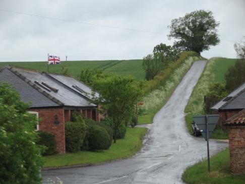
Two short walks today, rather than one long one. During the first, the weather was still grey and blustery as we set off along a bridleway opposite some recently renovated farm buildings, where the jubilee still lingered:

Image

Having no interest in the royals and still less in the Olympics, I can’t exactly say I’ve been caught up in all this fervour; if that’s what it is. In some countries, of course, it’s common for people to “fly the flag” all year round, rather than just for celebrations of whatever kind. That always seemed a bit redundant to me, and slightly odd; as though they needed to remind themselves which country they were living in. It still seems a bit unnecessary and almost “belligerent”, somehow; and I’m glad we don’t normally do it.

In contrast to the “barbed wire alley” walk the other day, today’s was nicely wide and open – as you’d expect from a bridleway.

It was a steady climb, at first – a little steeper than it appears on the photograph – with a wood plantation to one side, which was full of Campion. Then, something of a drop down the other side of the rise, to a stream:

Where the wood ended, it was possible to see up the valley to the west:

as well as east, towards St James spire again:

At the valley bottom, turning east was strictly for horses only, apparently. Unfortunately, G can’t read and enjoyed a brief gallop:

…before we turned west. We passed another ‘picnic’ scene; this time where a fox had found some pheasant eggs before sloping off back to his covert. You can see his exit route through the weeds:

A short way further and we came to a pasture which, a sign said, had benefitted from a government countryside stewardship scheme. Financial incentive – from taxpayers –  for landowners to sort of leave things alone, in a nutshell. Sorry that the photos become blurred; we were facing the rain.

It looked to me, from the terrain, as though it wouldn’t have been used for anything more than pasture in any case and, apart from a very few cowslips, the vegetation was basically what anyone would get after not cutting their lawn for a while. The entire length of the pasture was also full of practice jumps for people on “horsey holidays”, which doesn’t do it any favours, visually, even if it does get the equestrian blood pumping.

In the afternoon the weather was much brighter, so we took ourselves off to find another dead village. Well, it certainly wasn’t looking too good.

It’s called Biscathorpe: another Danish settlement, by the name, although I found some brief mention on the ‘net of an archaelogical study that had found Roman glass there. They weren’t sure if it was from a bottle or a window. The walk is another part of the Viking Way, and this section starts off by the roadside and skirts the edge of a small wood on high ground:

From there, through a kissing gate (which seem to be rapidly replacing stiles around here) and the view is over wide fields where the river turns east to meet a tributary stream from the next valley over before heading south again:

Where the ground rises in the middle of the photo is the line of what looks like it was once a substantial roadway; as can be seen in better relief from a little way down the slope, looking back:

We followed the ‘road’ down, past some old gnarled hawthorn trees that are all that remains of an ancient hedgeline:

Closer inspection shows where hedgelaying had been done (a means of strengthening a hedge’s bulk by hacking and interweaving the shrubs and trees that make up the hedge growth), a very long time ago. No doubt the cattle in the field find these very useful for scratching themselves with;  or even ‘withal’:

Below this hedgeline there are earthworks which are all that remains of the medieval village which no doubt formed the bulk of the 19 households that were recorded for the Domesday Book:

Of course, such earthworks never do look very impressive from ground level.  An aerial view always gives a much better idea of the field and village layout. The wood we started from is towards the top and left of the picture. The hawthorn hedgeline is towards the centre:

We carried on, down to the quietly gurgling river and over the sturdily built cattle-safe gated bridge, heading for the church:

And this is what we saw first:

This is usually called the Old Vicarage and latterly, as there hasn’t been a vicar here for many a year, the Church Cottages. There were certainly people living here the last time I visited the area, though that was over ten years ago. I don’t know how long it’s been empty, or whether there are any plans for the place, or if it’s just doomed to fall down. Sad to see it looking so bleak, though, in such a peaceful, pleasant place.

There used to be a couple more labourers’ cottages in a remote spot overlooking this valley, to the east; but they’d been derelict for some time and now seem to have gone altogether. According to John M. Wilson’s Imperial Gazeteer, there were 90 people living here, in 11 houses (!) in 1872. Now there are only three or four inhabited houses left, up the hill to the south, and a working farm.

Just behind the Vicarage, hidden behind a mass of yew trees, is the church itself, also suffering from a bit of neglect:

Churches don’t seem to have had much luck, here. According to the records, in 1783 a marriage had to be conducted in a nearby church because Biscathorpe’s had been “taken down for repair”; which sounds to me like a rebuild. In 1850 the church was definitely completely rebuilt: and then renovated again in 1913.

As you can see, it’s cement rendered and, where this has crumbled away there lies revealed the actual building material: the usual soft stone rubble that is probably the main reason so many churches here have had to be rebuilt so often:

There’s just no decent stone to be had locally; it’s a matter of geology. And it’s very expensive to import. Though rendering definitely doesn’t work for me, I do like the style of decoration on this church, but it doesn’t seem all that ‘permanent’. More of a confection:

..but I was surprised to find it unlocked. That must be quite rare, these days. Inside, again a  little neglected: damp showing through the plaster, which is just beginning to crumble, but the woodwork seemed pretty much intact:


The place doesn’t seem to have had much more luck with its clergy either. The Parish register – not much of which is in good enough repair to be legible, apparently – only goes back as far as 1688, so I still haven’t managed to find out the name of the parson, incumbent here, who took part in the doomed and perhaps slightly farcical Lincolnshire Rebellion of 1536 (which did, however,  inspire the also unsuccessful Pilgrimage of Grace) and may well have got him hanged, the following year, along with other rabble-rousing churchmen. Another was complained of, by the curate who followed him, for being too indolent to record births marriages and deaths there, between 1807 and 1810, “much to his discredit”. In fairness, there probably wasn’t that much to record…

Oh well, it’s all been downhill from the Danes and Domesday, apparently; but,  though Biscathorpe may well be on the way to disappearing altogether, the river will, as ever, carry on…

Wettest. drought. ever.

… and still we have a hosepipe ban. Braving the wet and stinging gales, we went briefly into town today, parking up and walking through this park, down to the bridge:

Image

It’s called “St Mary’s Park” and, as the name implies, there was once a church here – the earliest known one in the town (if you don’t count the 7th century monastery which was destroyed by the Danes). St Mary’s was built around 1170 and rebuilt in the 15th century but it “fell into disuse”, as they say, and by 1650 there was little physically left of it.

There’s no mystery, I suppose, about why churches are no longer being used nowadays, but I can’t help feeling a little curious as to why it should happen in those decidedly non-secular times.

Perhaps it was something to do with the fact another church – St James’ – was built close by, in 1380, on what was probably the more populous side of the river, even then. Perhaps the new church was bigger and/or better. One of them flourished and the other declined; that much is certain. Fluctuations in the population, if we can call it that, may well have had something to do with it. A populace no doubt hard hit and struggling to recover from the Black Death was apparently hit by further outbreaks of plague in 1587; then again in 1625 and once more in 1631, which itself carried off over 700 townsfolk, probably the greater part of the people there.

Whatever happened, by 1650 it was gone, but the plot continued to be used as a burial ground and became busier as such, of course, as the population rose again through the 17th and 18th centuries. In fact, it became so busy that eventually old bones, so to speak, were having to be unearthed and disposed of to make way for new interments. It is said that the restless shade of one person employed in this grisly task still haunts the place; pushing his squeaking, spectral wheelbarrow along the path…

Anyway… by the 1850s the population  was about 10,000; and a new public cemetery was opened on the south side of the town. St Mary’s burial ground, in it’s turn, fell into disuse. Eventually, the gravestones were moved and the plot cleared to become the park we see today. The stones were, for some reason, stacked against the wall, to the west:

It isn’t, I suppose, the most disresepectful thing that could have happened to these supposedly “permanent markers”. I’ve seen such stones broken up before – though not in this town -and used to pave the walkways of a peace garden. I’m not religious, but that did seem a little insensitive. Still, stacked they are and shortest to the front, rather than – alas – the most interesting, in some cases. A tireless local historian, now gathered to his own long home, reported that some of the inscriptions on these stones were recorded at the time of their removal  including one which read:

‘In this place are deposited the remains of Thomas Mason Surgeon who departed this life August 5th 1815 aged 25. Stranger or friend, here stop and shed thy tears over the tomb of departed usefulness: his sun of life had scarcely beamed into meridian splendour, and was shedding its peculiarly vivifying influence around ’ere it was obscured by a dark and fearful cloud. Alas it has set prematurely in the grave, Reader, let this impress thee with the uncertainty of human life: depart then and improve the short space thou has left in doing all the good thou canst’.

I wonder what that little lot cost…

However, for the more morbidly inclined, here are some of the ones on view:


At the southern end of the park, you can look down on some pleasant gardens by the river:

And across to the smug, surviving, much improved St James:

Walking further into town, we next come to a bridge over the river itself. You wouldn’t think so now, but this tranquil scene belies a watercourse that burst its banks in fury, in 1920, taking many buildings with it:

It’s even prettier on the other side:

On this side there is also a mill race:

And, of course, although there’s no longer a wheel, the mill itself:

It was built in 1755:

On the bridge side of the building is the flood level marker. Apparently, on the day in question,  a bad storm gathered and, instead of passing on, circled around the same hills just west of the town pouring its load and swelling the many tributary streams that fed the river. The river swelled likewise, but the water built up behind a wall of detritus, somewhere, and then suddenly released – sending a sudden destructive wave through the town. I’m sure this is well documented elsewhere on the net.

On the first side of the bridge there is now a wall where once several terraced houses stood. The flood destroyed them, as well as many other buildings much further along the way, and the bridge itself.  23 people died. http://www.youtube.com/watch?v=0d2ZS6Rm__4

A better view of the church spire, below. It’s the tallest church (i.e. not cathedral) spire in the country, I believe.

Ok, you’ve suffered enough for one day. I’ll save some photos of the rest of town for another occasion. There’s a little more history to the place and even a few more ghost stories to beguile your time, but I’ll leave you with one more glimpse of the kind of town we’re dealing with:

Stay dry!

Flaming June…

..is cool and rainy. Looks like we’re in for another disappointing Summer. It’s seems like a pattern has been establishing itself over the past few years. A brief flash of hot weather in the Spring, and then nothing but rain and wind until September.

Still, it was dry enough today to persevere with the gardening; planting the hanging baskets with some on-sale supermarket lobelias; late pruning; cleaning and reorganising the two little greenhouses I somehow managed to find room for, but haven’t used much. The plants I used to keep there were yet more victims of the Bad Winter of 2010, so I’ve just used them as ‘potting sheds’ and for storage since then. They still need scrubbing every year, between the birds, pollen and that green, powdery algae which is apparently a sign that the air is clean, at least.

It was nice to see the rhododendron recovered and doing well:

It’s been growing in a pot for a few years – the soil in the garden isn’t acid enough to plant it there. I have one or two progressively larger pots in which to replant it, when it becomes necessary. Thereafter I suppose I’ll have to transfer it to the woods. Some of them already have rhododendra (?) flourishing, from the times when they were privately owned.

It seems to be a darker shade of pink, this year; but that may be my imagination.

I wish I enjoyed gardening more. I’d like to say that working with the plants induced in me that particular engaged state of Zen-like no-mind peculiar to gardeners, but it doesn’t. Actually, between you and me, I think that’s just a smokescreen: as being a true gardener can require a certain ruthlessness – as well as immunity from boredom – which I don’t seem to possess. Anyway, I usually keep my mind off it (and occupied) by listening to things on my MP3 player. Today, it was an audiobook version of “The Road” by Cormac McCarthy. And I did the same while trying out a new walk for the dogs, this afternoon.

I have a few favourite sources of humour on the internet and one unexpected source has sometimes been the “customer reviews” on Amazon. I would certainly recommend the one-star reviews of The Road: written by people who seemed outraged to think a post-apocalyptic novel should be so bleak and depressing. Apart from pointing out the author’s apparent need to “Cheer the —- up!”, quite a lot of umbrage was taken at the liberties he apparently takes with punctuation and grammar; but these didn’t really come across in the audio book version. It “read” very well, considering an apparent debt to Hemingway in the style, with the odd flight of purple prose thrown in: some of which was quite baffling. What are “secular winds”? Since when was “sorrow” a verb?

Our footpath started by the side of a farmhouse. Not a good sign, in my experience. This one was still flying a Union Jack from the weekend’s royalty-fest:

And, sure enough, we were welcomed with a somewhat overboard display of barbed-wiring, encouraging walkers  to keep to an apparently well-begrudged corridor through his land of hope and glory:

Though I hadn’t read the physical book before hearing the (unabridged) audio, I had seen the film (a reversal of the usual experience, I suppose) and I knew from that experience, there had to be more to the story than what had been on the screen. Not that I thought it a bad film at all; but there isn’t a lot of dialogue and much of the power of the book comes through the narration and description. On the screen you mainly get the protagonists’ bleak, plodding struggle for survival under the grim skies, and through the grey half-light of a nuclear winter: wonderfully well-depicted, but a tad monotonous in cinematic terms. Imagine trying to film a Beckett novel.

If you haven’t already read/heard/seen it, I wouldn’t hesitate to recommend it, though some people think it should come with a health warning. It is bleak; all the more so for being all-too-believable.

At the top of the rise, there were some pleasant views to admire (in spite of what was going on in my ears) while we struggled with the ‘kissing gates’; and, down the other side, the path followed the line of a tall hawthorn and rose hedge, through which we could see what some of the fuss was about: cattle and calves:


Down on the lower ground, there were sheep in the meadow:

and a few more flowers. But, as we got closer to the village, a storm started to gather quite rapidly:

And so, where the path was narrowing in any case, to a viewless tunnel, we decided to turn back before it started raining:

Fortunately, we managed to leave the rain down in the valley and made it to friendlier upper ground of the drover’s road safe and dry:

I hope the weather is much better where you are.